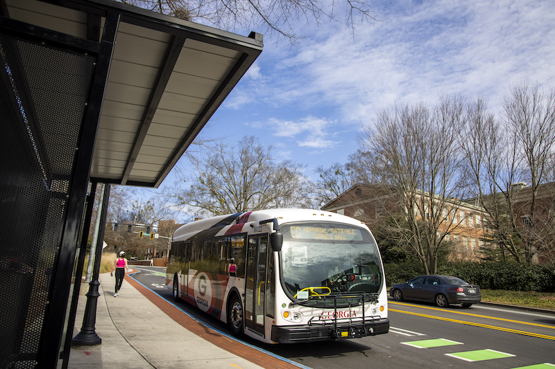
Weekday Bus Routes


UGA Transit system utilizes 12 routes to move members of the campus community from every corner of campus in a timely manner and is constantly looking for ways they can improve and evolve to meet the needs of faculty, staff, students, and visitors. Read more about the support and efficiencies of these routes here.

UGA bus routes are subject to change based on campus need and as we navigate how to better serve the UGA community during the COVID-19 pandemic. Live track the bus on the UGA App or on routes.uga.edu for the most accurate information. Limited bus service is provided during university holidays, Finals, Maymester, and Summer sessions. Regular UGA bus service does not run during home football games, when the university is closed or the weekend immediately before or after a holiday.

Please note: Gillis Bridge on Sanford Drive will be closed to all vehicular and pedestrian traffic beginning at 7 p.m. on Fridays before home games and will reopen following each game. This affects both UGA and ACC transit routes. UGA affected routes are: East Campus Shuttle and Prince-Milledge. Northbound detour stops for these routes will be at Gilbert Hall and opposite Rutherford Hall; Southbound detour stops will be at Correll Hall and Rutherford Hall.  To view a map of these detours, please click here.


Weekday Route Schedule

Monday – Friday: 6:30 a.m. – 7:45 p.m. 

Click here for information on night & weekend routes.


Gameday Fridays

Gillis Bridge will be closed to vehicle and pedestrian traffic at 7:00 p.m. on the Fridays before home football games and will reopen after each game. This closure affects both UGA and ACC transit routes.

UGA buses will begin following detours away from Sanford Drive at 5:00 p.m. on Fridays and will resume normal operations on the Sundays following a home game.

For more information about the bridge closure and other Sanford Stadium improvements, please visit the UGA Athletics website.


Additional Information:


Information by Route

Central Loop

Map of Central Loop.Route Description:

This route carries riders to and from the central points of campus with stops at the major hubs of the Main Library, the Tate Student Center/Memorial Hall area, north campus, east campus, and south campus.

Bus Stops:

  1. Memorial Hall
  2. Gilbert Hall
  3. The Arch
  4. Main Library
  5. Tucker Hall
  6. Joe Frank Harris
  7. University Health Center
  8. East Campus Village (ECV)
  9. Aderhold Hall
  10. Plant Sciences
  11. Science Learning Center (SLC)
  12. Snelling Dining Commons
  13. Physics

Timing:

Intervals may vary.

North South Connector

Map of North South Connector route.Route Description:

This route carries riders to and from central points of campus with stops at the major hubs of north campus, the Tate Center/Memorial Hall area, and south campus, including Driftmier Engineering Center.

Bus Stops:

  1. Tate Student Center
  2. Physics
  3. Myers Quad
  4. Coliseum
  5. Coverdell
  6. Driftmier
  7. Building F
  8. Tucker Hall
  9. Training and Development (on Thomas Street)
  10. Main Library
  11. Psychology/Journalism (PJ)

Timing:

Intervals may vary.

East Campus Shuttle

Map of East Campus Shuttle route.Route Description:

This route carries riders to and from the Intramural Fields Deck and east campus to Ag Hill, Tate Center/Memorial Hall area, and the Terry College Business Learning Community.

Bus Stops:

  1. Memorial Hall
  2. Gilbert Hall
  3. The Arch
  4. Main Library
  5. Psychology/Journalism (PJ)
  6. Tate Center
  7. Physics
  8. Connor Hall
  9. STEM Building
  10. Tucker Hall
  11. Joe Frank Harris
  12. University Health Center
  13. Intramural Fields Deck
  14. Intramural Fields Lot EO1
  15. East Campus Village (ECV)
  16. Tucker Hall
  17. Food Science
  18. Chemistry
  19. Physics

Timing:

Intervals may vary.

West Campus Shuttle

Map of West Campus Shuttle route.

Route Description:

This route carries riders to and from the first-year high-rises and low-rises, the Terry College Business Learning Community, north campus, and the Tate Center/Memorial Hall area.

Bus Stops:

  1. Finley at Russell Hall
  2. Oglethorpe House
  3. Rutherford Hall
  4. Physics
  5. Memorial Hall
  6. Gilbert Hall
  7. The Arch
  8. Athens Transit Multimodal Center (MMC)
  9. Main Library
  10. Psychology/Journalism (PJ)
  11. Correll Hall

Timing:

Intervals may vary.

Cross Campus Connector

Map of Arch Express route.

Route Description:

This route carries riders across campus with stops at several major hubs in West, South, and East Campus.

Bus Stops:

  1. Memorial Hall
  2. Correll Hall
  3. Finley at Russell Hall
  4. Oglethorpe House
  5. Rutherford Hall
  6. Conner Hall
  7. STEM Research
  8. Tucker Hall
  9. Joe Frank Harris
  10. University Health Center
  11. East Campus Village (ECV)
  12. Tucker Hall
  13. Food Science
  14. Chemistry 
  15. Physics

Timing:

Intervals may vary.

Bulldog Housing

Map of Bulldog Housing route.

Route Description:

This route carries riders to and from the University Village area, Driftmier Engineering Center, the Student Learning Center, Memorial and Correll Hall, south campus, and east campus.

Bus Stops:

  1. Building S
  2. Building Q
  3. Building P
  4. Rogers Road
  5. Building G
  6. Driftmier
  7. Science Learning Center (SLC)
  8. Snelling Dining Commons
  9. Physics
  10. Memorial Hall
  11. Correll Hall
  12. Black-Diallo-Miller Hall
  13. Creswell Hall
  14. Oglethorpe House
  15. Rutherford Hall
  16. Myers Quad
  17. Coliseum
  18. Aderhold Hall
  19. Joe Frank Harris
  20. University Health Center
  21. Building H
  22. Brandon Oaks
  23. Jamestown

Timing:

Intervals may vary.

Park & Ride

Map of Park & Ride route.

Route Description:

This route carries riders to and from Park & Ride to major hubs on campus. This route services east campus, the Tate Center/Memorial Hall area, Ag Hill, and the Intramural Fields.

*Park & Ride will stop at Intramural Fields on inbound trip to campus before 12 noon at which time it will switch to making Intramural Fields stops on outbound trip.

Bus Stops:

  1. Park & Ride (off College Station)
  2. Opposite Ag Tech (On Demand)
  3. Intramural Fields Deck
  4. Intramural Fields Lot EO1
  5. East Campus Village (ECV)
  6. Tucker Hall
  7. Food Science
  8. Chemistry
  9. Physics
  10. Memorial Hall
  11. Human Resources
  12. Spring Street at Thomas Street Intersection for Tanner Building/Training & Development
  13. Tucker Hall
  14. Joe Frank Harris
  15. University Health Center

Timing:

Intervals may vary.

Vet Med

Map of Vet Med route.

Route Description:

This route services east campus and carries riders to the Veterinary Teaching Hospital off of College Station.

Bus Stops:

  1. Vet Med (off College Station)
  2. PDRC
  3. Park & Ride (off College Station)
  4. Opposite Ag Tech (On Demand)
  5. East Campus Village (ECV)
  6. Aderhold Hall
  7. Plant Sciences
  8. Coverdell Hall
  9. Driftmier
  10. Building F
  11. Intramural Fields (on College Station)
  12. Park & Ride (off College Station)
  13. River’s Crossing
  14. Opposite PDRC (On Demand)

Timing:

Intervals may vary.

Health Sciences

Map of Health Sciences route.

Route Description:

This route carries riders from main campus to the Health Sciences Campus. 

Bus Stops:

  1. Health Sciences Campus
  2. Lucy Cobb
  3. Clarke Central High School
  4. Springdale Street
  5. Oakland Avenue (to Five Points)
  6. Lumpkin Street at Rutherford Street (to Campus)
  7. Snelling Dining Commons
  8. Physics
  9. Memorial Hall
  10. Gilbert Hall
  11. Nacoochee Avenue (On Demand)

Timing:

Intervals may vary.

Milledge Avenue

Map of Milledge Avenue route.

Route Description:

This route carries riders from the Main Library and Tate Center/Memorial Hall area in north campus to Five Points in south campus and up Milledge Avenue. 

Bus Stops:

  1. Tate Center
  2. Physics
  3. Myers Quad
  4. Presbyterian Center
  5. Lumpkin Street at Rutherford (to Five Points)
  6. Oakland Avenue (Tri-Delta)
  7. Rutherford Street
  8. Peabody Street
  9. Henderson Avenue
  10. Waddell Street
  11. Newton Street to Downtown
  12. The Arch
  13. Main Library
  14. Psychology/Journalism (PJ)

Timing:

Intervals may vary.

Greenhouse Shuttle

Map of Greenhouse Shuttle route.

Route Description:

The route services Plant Sciences bus stop for riders needing to get to the UGArden off of Milledge Avenue.

Bus Stops:

  1. Plant Sciences
  2. Driftmier
  3. Soccer/Softball
  4. Botanical Gardens (On Demand)
  5. UGArden (On Demand)
  6. Campus Transit (On Demand)
  7. Complex Carbohydrate Research Center (CCRC)
  8. Automotive Center (On Demand)

Timing:

Intervals may vary. (This route runs from 7:00 a.m. -7:00 p.m.)


Chicopee Shuttle

Map of Chicopee Shuttle route.The route services riders from the main campus to Chicopee Complex.

Bus Stops:

  1. Chicopee Complex
  2. Main Library
  3. School of Social Work

Timing:

Intervals may vary. (This route runs from 7:00 a.m. -6:30 p.m. with the last departure from the Main Library at 6:15 p.m.)